Lands end and John O groats sign > photograph charges

The famous Signposts at Lands end and John O groats attractions :

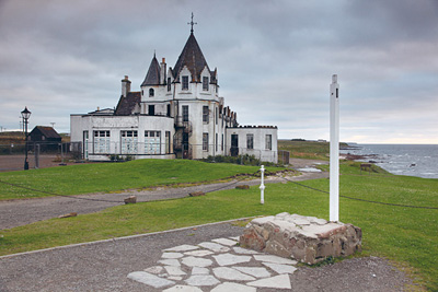
John o' Groats

John o' Groats not the most northerly point in the UK Mainland

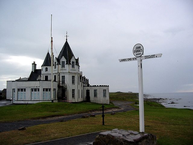
These famous signposts and the sites themselves at either end are both owned by the same business “Heritage Attractions Limited” or is it “Heritage UK” ? at either end of the country, a name designed to make a private company try to sound like it’s a national government backed agency or something, and in opening hours during the tourist season there is a charge of £10.00 per person to take your photograph next to the infamous signs at either end of the journey, for this you get an an 8 x 10 print posted anywhere in the UK and they put the lettering up on the sign etc, which is ok value, but to be honest, admiteadly its not more than thorpe park would charge for a photo on a log flume or something, but I dont think that either end of the “end to end” should be turned into some kind of themepark ? and since practically every one has a digital camera these days, this service in my opinion is just milking it too far, and after hours and out of season the sign is reduced to a plain post as both directional fingers and the roundel on top are removed to prevent people from getting their evidential photograph standing next to the sign for free, which seems to me demonstrate something of the kind of highland welcome they should not be promoting in their tourist industry ? I should not get too aggressive at John Carter who I believe is still the photographer in question ? as many have said he’s a nice enough guy ? but I cannot vouch for what goes on at John O Groats, no doubt there some local/familial and private investor squabbling that goes on, that can often turn, once lovely locations like this into somekind of hotbed of powermongering and plotting to control some ailing tourist cash register, as is the case with most private ownership in this country.

John o Groats no fingers no roundel

John o Groats no fingers no roundel

the photo is borrowed from a very good article about the general sorry state of john o groats in a great article on urban realm which can be read by clicking this link, they also seem to run something called the carbuncle award, which surely has too many contenders architecturally in britain

This seems uncivilised, that both these sign locations are privately owned, they should obviously be free as when people come to these uk furthest points, they will spend money in the facilities on site and the nearby area anyway, therefore people should be able to freely take their own photograph next to the signs, or perhaps english heritage should purchase them ? as currently this charge sadly bookends what by foot is a personal and epic pilgrimage of britain, with a really touristic tacky experience at either end, quite unpleasant, and not british in nature.

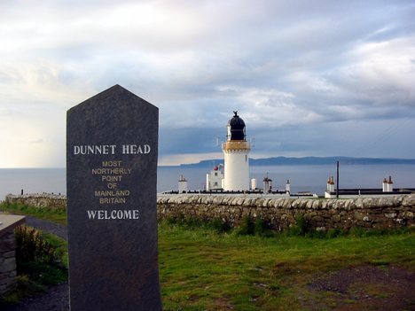
Dunnet Head

Dunnet Head the real most northerly point on the UK mainland

Dunnet Head the real most northerly point on the UK mainland

dunnet head

Dunnet head is in fact the geographically most northern point on the UK mainland, and John O Groats is the grockle cash register they built at a convenient ferry crossing point, they want you to visit to spend your cash, which apart from it being geographically incorrect, wouldn’t be so bad if they hadn’t run to the extent of charging you to stand next to the sign ? which is egregiously money orientated, after all tourists would no doubt spend money there, but to be charged for standing next to a sign is just plain cheap and gouging ! My advice get your journey stamped in the post office > take your photo next to the dunnet head sign, and visit john o groats for a bit to eat and drink, and you if you feel the necessity of the sign itself being in your photo album then pay for that also, as regardless of how crass it seems to pay for a photo with a sign, its no worse than any other horrifically over commercialised places in the UK.

to resume :
toilets are 20p (sadly most of the public lavatories have gone) I blame cottaging and weak councils)
a cup of tea at John O groats ? no idea anyone got any experience on that front ?
take your photo with the sign > £10.00 larger photos cost more. once youve paid you can also take digital photos too.

OS footpath dataset govt

This argument is as old as the hills and full of greedy behaviour.1 The Ordnance survey data , in its inception though founded by royal charter and even today funded by council planning , when theyre funding is traced back, it fundamentally stems in one way or another from the general publics purse, this is fundamentally “our data” regardless of how they would like to couch copyright issues and fundamentally we still as individuals dont have access to it, of course commerical use should be paid for, though difficult to restrict if personal use were free, but basically we want our data, maybe it should be done that they release all data that is older than 10 years that way we would get nearly all footpath data and pubs etc without affecting there current business in planning data as that needs to be up to date, to take into account modern developments. At the moment we are left in a situation in which ordinary people in openstreetmap are remapping all the stuff that has already been mapped by the OS, which is ridiculous.2 What we fundamentally need as individuals is access to the footpath and hostelry data for free on digital handheld devices, as this would make walking these footpaths for the average person much more feasible, this i currently not possible, The Os charge for this data in the form of maps.3 AN iphone can store 64gb of data, I want 1:10,000 the whole country on my handheld device at my disposal and I dont see why they balk at the idea, the data they have released into the public domain deliberately didnt include footpath data or pub locations and much other stuff, basically making it useless from a walkers perspective.4 The OS and the councils and copyright issues are both standing in the way of human progress, by artificially limiting this data.5 We want openstreetmap to be given OS data at 1:10,000 for the whole country in kml format, at least we could guarantee that they as a body wont try and screw us for our own data as theyre remit is for open data and always will be.

still there isnt free footpath data in digital form from the OS

complaint to the ordnance survey

I wish to make three complaints

1: as a person who has a degree in Graphic information design, turning the symbolic old symbol of christian churches a cross into the letters of PW (place of worship) how bloody non descript and weak an expression, this is an abomination, which person / pressure group organised this symbols swap to letters scenario ? the eye then has to differentiate this text from other text this isnt as efficient for the eye as differentiating a symbol from text which has a greater natural graphic seperation in the first place, this has no doubt be done to appease some ethnic groups somewhere, i find it denigrating and personally offensive that you have done this, not that im am in anyway part of any organised religion, as a graphic purist you are removing usefull information from the map, even if its a mosque (crescant symbol) … i want to know, if its a church (the old cross symbol) i want to know, small overly PC cowtowing no doubt idiot government approved of chivying denigrations such as these are continuously damaging my culture, it offends me your organisation gives way to this idiocy.

2: the “GetaMap” service (nice marketing slogan led era we live in today) well its a really great service, build your own walk with waypoints … stopoffs … point of interest …walking times … fantastic ………up to the point …… at which you need to use the information ? if i can’t get the route that ive constructed on the getamap website as anything other than static A4 printout for a £1, how really usefull is it to me in this technological age ? did you think about the environment and wasted paper you are creating with this one decision alone ? I guess you think your saving the environment compared to people buying full maps which are printed, I need it as digital information to go into a gps smartphone/iphone so I can live track myself on my route with all the points of interest and pubs as an itinerary, with perhaps a virtual walker on the same route travelling at my estimated speed so I can see whether im ahead or behind my schedule, then it would be a truly amazing service.

Do you fear … that you might be giving the people to much information from the information pile, they have paid you to collect in the first place ! whether as in your founding by charter of a warring king who taxed his people to pay for you, or through all the moneys that ultimately flowed from the people over the years to your organisation. I dont believe you should have no ways of generating revenue, I just believe that you should be making most of your money from commercial organisations, planning etc and not individual walkers.

oh there is memorymap digital maps … I hear you say ? well I’d only need 69 of those at £100.00 ie £6900 to get the whole of the UK at 1:25000 not even 1:10000, i would truly love to know what the vector based(ie not as images) dataset of britain at 1:10000 would be digital data size wise with all the information relevant to walkers, 32gb ? 2tb ? which ever way the idea that this could be squeezed into a handheld gps navigating device, seems possible to me.

3: The fact that in this day and age I still cannot get access to a whole or protions of a free 1:10000 digital footpath map for my own country is an embarassment for the OS, long may openstreetmap continue to grow and be contributed too by the ordinary public, so that one day we do have an organisation that is open and for the people in this digital age rather than being dependant on a public exploiting organisation like the OS, so that we the people can have our footpath knowledge for ourselves in a digital form, after all it was the ordinary people and the drovers and hard working sods over thousands of years of drudgery, who created the majority of the paths with their footfall in the firstplace. the footpaths are one of the small remaining symbols of some of the last public ownership and rights in this country that no matter how poor and disenfranchised you maybe in society, you can take advantage of on a nice walk, in a nation so consumerist, overmarketed, fractured, divided, outsourced, privatised and apportioned into the hands of the selfish few and private wealth international ownership brigade, it is a tragedy you dont make this footpath data freely available to people.

A British Native